Chermside & Districts Historical Society
Chermside -
1980s to now
Originally written by Pat O’Shea, 2010. Updated by Sherry Mackay, Julia van Zon, Bradley Scott, 2023.
Chronology of Chermside 1988-2012
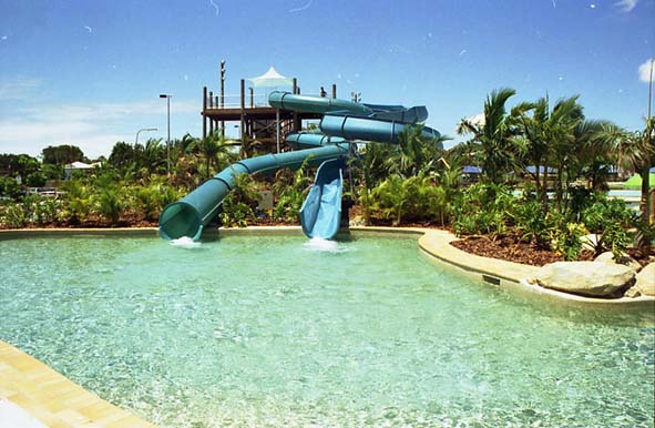
Chermside Aquatic Centre, c. 1996. Image courtesy of Brisbane City Council Archives.
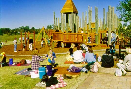
Kidspace in 7th Brigade Park, c. 1996. Image from CDHS archives.
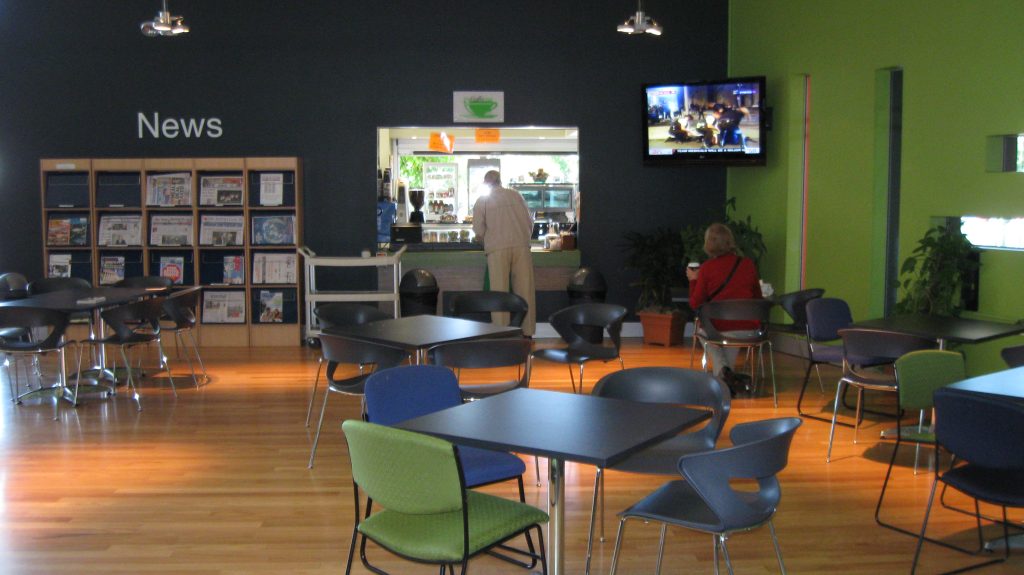
The new cafe in the expansion of the Chermside library, c. 2009. Image courtesy of Brisbane City Council archives.
1992: Kedron Wavell RSL installs 45 poker machines.
1992: The Australian Tax Office was built on the corner of Gympie Road and Banfield Street.
1994: Brisbane 2011 The Liveable City of the Future Plan.
1996: Chermside Regional Business Centre amended to allow the Centre to expand north of Banfield Street into Commonwealth land occupied by Telstra at the time.
1996: Chermside Aquatic Centre replaces the Olympic Pool (built 1964).
1996: Kidspace opened in 7th Brigade Park.
1996: Westfield bought Chermside Shopping Centre.
1997: New Brisbane City Council library was built on the corner of Kittyhawk Drive and Hamilton Road and was the first Regional Library in Brisbane.
2000: Northside Regional Business Centre opened.
2000: Kedron Wavell hockey fields opened (one synthetic and two grass fields).
2000: Chermside Veterinary Hospital expanded (Green Cross).
2001: Holy Spirit Hospital Northside opened beside The Prince Charles Hospital (now called St. Vincent’s Hospital).
2004: Expansion of the Chermside Library with a $2m upgrade, includes meeting rooms, café, and more book shelving room.
2004: Aldi Supermarket opened on Gympie Road.
2005: Southeast Queensland Regional Plan released with Chermside designated as a growth hub.
2005: Chermside Major Centre Local Plan was released to allow high-rise residential and business premises in a much larger area than in 1987 and 1996.
2005: Chermside set to dominate the north Brisbane landscape as the area’s growth hub through the South-East Qld Regional Plan. Chermside is recognised as a Primary Activity Centre in the plan.
2005: First high-rise residential in Chermside. Chermside Central has nine levels in Playfield Street.
2011: Another six high-rises on Playfield Street and five more nearby and another one in 2012.
Chermside Regional Business Centre 1987
The aim of the Brisbane City Council in rezoning this area was to attract high-rise business offices from the Brisbane Central Business District. The area was bounded by Gympie Road on the west, the Downfall Creek on the north, Kittyhawk Drive on the east, and Hall, Thomas and Charlotte Streets on the south.
The inner part was for the already-existing Shopping Centre and, later in 1996, allowing it a northward extension over Banfield Street to Downfall Creek.
The only enterprises to build in the area were the Australian Taxation Office, rising nine levels making it the tallest building in Chermside at that time and the Commonwealth Building, both in Banfield Street.
The old Australian Taxation Office is a very large building and dominates the northern skyline of Chermside. This is the south face as seen from Banfield Street.
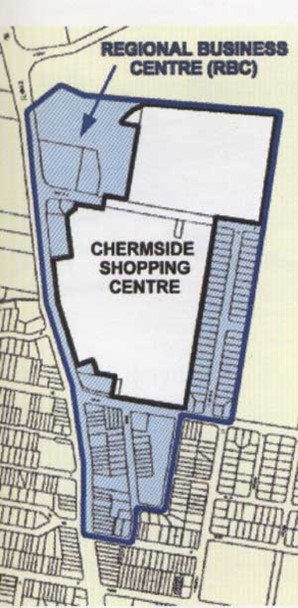
In 1987 the Brisbane City Council rezoned the area marked in blue around the Chermside Shopping Centre as the Chermside Regional Business Centre. The white area north of Banfield Street may have been left for Shopping Centre expansion. In 1996 another rezoning took place to allow the Shopping Centre to expand northward over Banfield Street to Downfall Creek. This had been the site of a Telstra training area since the 1940s. (Brisbane City Council Map 1997)
Chermside Major Centre Local Plan 2005
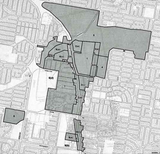
With the failure of the plan to attract businesses to Chermside the same area was again rezoned to allow high-rise residential and some commercial development.
Further changes took place in Chermside due to the State Government drawing up the South-East Regional Plan in the early 21st century.
In 2005, Chermside was designated a growth hub and became a Major Centre with a Local Plan drawn up to allow high-rise residential and business premises in a much larger area than the earlier Regional Business Plan of 1987 and 1996. It also included extra zones not covered in the earlier plans. The new plan extended it west over Gympie Road and south to Kitchener Road in Kedron.
Hospital complex and other medical facilities
The Prince Charles Hospital occupies an area of 90 acres or 36 hectares set on a ridge overlooking much of Chermside. It started in the early 1950s as the Brisbane Chest Hospital to treat tuberculosis and has gradually grown into a very large General Hospital with a world reputation in Cardiac care. It was joined by Holy Spirit Hospital in 1999 (now named St. Vincent’s Hospital) and together they are a health service for the surrounding area.
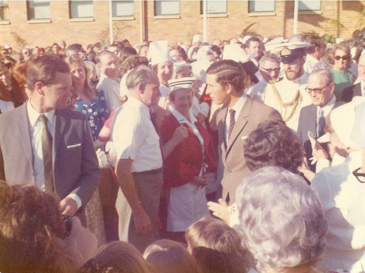
This candid picture is of Prince Charles mingling with the crowd at the naming of the Prince Charles hospital in 1974. He apparently quipped that he would have to come back and rename it when he became King… the time has now come King Charles!
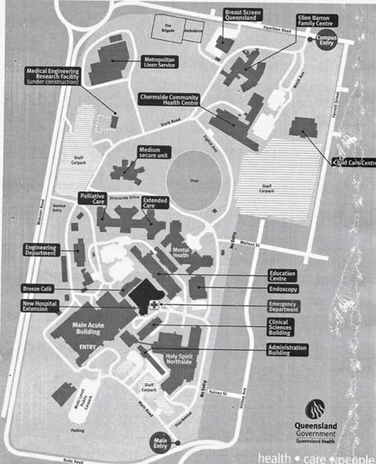
Plan of The Prince Charles and Holy Spirit Hospitals. Image courtesy of Queensland Health. Date unknown.
Aged Care and Retirement Centres
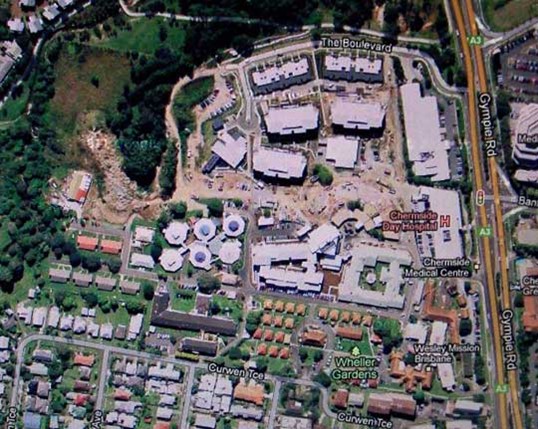
Wheller Gardens and Wheller on the Park, c. 2010. Image courtesy of Google Maps.
Wheller Gardens and Wheller on the Park, c. 2023. Image courtesy of Google Maps.
Wheller Gardens began in 1936 in the small cluster of red roofs in the foreground, the first aged care settlement in Brisbane. It expanded into one of the largest in the buildings across the lower part of the photo.
Wheller on the Park began in 2007 as a retirement village under the curve of The Boulevard. It is continuously expanding.
The upper of the two long white buildings fronting Gympie Road is the old Chermside Regional Business Centre now home to the NDIS. While the lower is the Chermside Medical Centre
Westfield Chermside Shopping Centre
In 55 years the shopping centre of Chermside has grown from:
1957 Allan & Stark Drive-in Shopping Centre comprised:
- 1 Department Store – Allan & Stark
- 1 Supermarket – Brisbane Cash and Carry
- 25 Specialty Retail Stores
- A total of 27 shopping outlets
- Floor Space: 6,000 square metres
- 700 car parks
2012 Westfield Chermside Shopping Centre:
- 3 Department Stores
- 4 Discount Department Stores
- 4 Supermarkets & Liquor
- 16 Cinemas
- 1 Bowling Alley
- 39 stand-alone ATMs
- 432 Specialty Retail Outlets
- A Total of 484 shopping outlets
- Floor Space: 123,740 square metres
2023 Westfield Chermside Shopping Centre
- 480 retailers
- 15 cinemas
- Floor space: 176,465 square metres
- 7,200 care parks
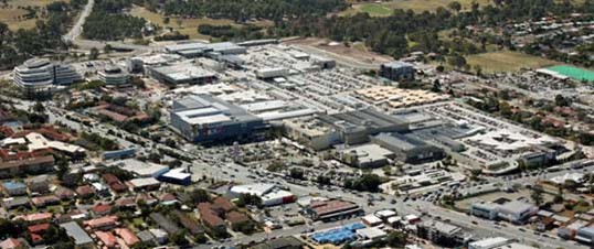
Photo of Westfield Chermside taken 6 August 2006 when the fifth expansion was nearing completion.
1958 image of Chermside Shopping Centre
This aerial photo shows the early stage of the Drive-In Shopping Centre, the houses on Playfield Street, and the vacant block of the Hamilton Road Reserve.
Detail from the 1958 aerial view showing the space available for expansion of the Drive-In shopping centre, the bush-covered elongated block which became the Chermside Hub and portion of the 1,200 homes already built.
2012 Google aerial image of the same area
This aerial map shows the mass urbanisation of the area compared to 1958, particularly with the development of high-rise buildings around Chermside Shopping Centre.
Murphy's Paddock Legacy to Chermside
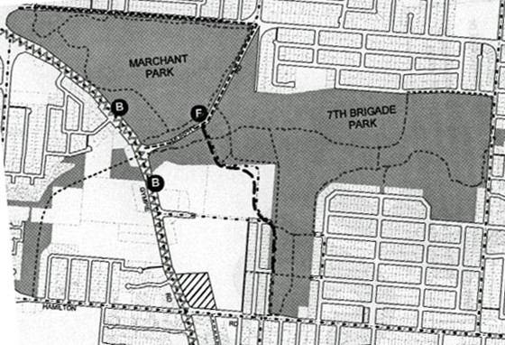
Of the original 203ha there is still approximately 113ha of open parkland. The dotted lines in the parks are the bikeways, the heavy dashed line is Kittyhawk Drive. (Major Centre Local Plan 2005)
A very important part of available space was due to the original survey which set aside the huge 203ha (504 acre) Murphy’s Paddock in the heart of Chermside. (See above Section – The Huxtable Survey.)
Murphy’s Paddock provided space for some 1,200 houses in the North-East and South-East corners, the 40ha (100 acres) of Marchant Park and the 73ha (180 acres) of 7th Brigade Park as well as space for the Library, Kedron-Wavell Services Club and the Aquatic Centre. The blank section above Banfield Street and marked by the letter B was Commonwealth land used by the old PMG and, later Telstra. It also contained the Tax Office and Commonwealth Centre.
In 1963 Brisbane City Council acquired the remaining 71 hectares of Sparkes’ Paddock from the Australian Government and renamed it the Hamilton Road Reserve.
This was followed by the building of the Chermside Pool in 1964, the Kedron-Wavell RSL Complex beginning in 1970, the Chermside Library in 1997 and the Chermside Historical Precinct in 2000.
In March 1996, the area was renamed 7th Brigade Park in memory of the men who trained here and fought so courageously at Milne Bay where they inflicted the first-ever defeat of the Imperial Japanese Army.
Thousands of young men trained here before moving on to the battlegrounds of New Guinea and the Pacific Islands; some 560 of them never returned and twice that number were wounded.
The blank section in the corner of Gympie and Hamilton Roads reaching north to Banfield Street and east to Playfield Street was Early’s Paddock and not part of Murphy’s Paddock. The Westfield Shopping Centre now occupies most of Early’s Paddock and most of the old Commonwealth land to Downfall Creek.
1975 Government Intervention 1 - change of boundaries
Chermside Boundaries pre-1975
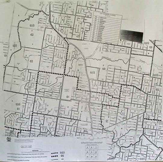
Map of Chermside pre-1975 when the size was 15.6 square km. The new suburbs of Bridgeman Downs and McDowall were not part of old Chermside but lay to the west. To track the boundary just follow the arrow heads. Image courtesy of The Australian Bureau of Statistics.
Chermside Boundaries post-1975
The current boundaries are much simpler than the old ones, especially on the east with Wavell Heights and the south with Kedron.
The western boundary is Webster Road which joins Gympie Road and moves south to Murphy Road and northeast to Navarre Street.
To Delaware Street, east to Newman Road, south to Hamilton Road, west to Pfingst Road, west on Calga Road, around Wavell Heights Primary School, south along Alleena Street to Rode Road, and west to Webster Road.
Chermside is now ‘landlocked’ and future horizontal expansion is very limited so most new expansion will be vertical.
The old boundary of Chermside was a complicated one which weaved and ducked around many streets. It was probably drawn up in the 19th century when settlements were scattered and it simply tried to include as many as possible.
Starting from the intersection of Hamilton and Trouts Roads the boundary went north along Little Cabbage Tree Creek to Albany Creek Road and turned south along Gympie Road.
East into Ellison Road, south into Newman Road, east into Buhot Street to Bilsen Road.
West into Main Avenue, south into Stadcor Street, east into Hamilton Road, south into Bilsen Road to Rode Road.
South-west into Edinburgh Castle Road and south into Imbros Street, across Buckland Road to Brook Street and along Kedron Brook to near the end of Nelson Street.
From the Brook to Tenth Avenue, via Kira Street to Eleventh Avenue, to Culgoola Street, to Fourteenth Avenue, to Edinburgh Castle Road and Gympie Road.
North to Kitchener Road, west to Maundrell Terrace, north to Rode Road, west to Trouts Road and north to Hamilton Road.
Chronology of Chermside 2012-today
2012-2015: There was a focus on developing Chermside’s infrastructure to support its growing population. This included improvements to public transport and road networks. The Prince Charles Hospital in Chermside also underwent significant expansion during this time.
2016: Westfield Chermside announced another major expansion, adding a new dining and entertainment precinct. This expansion aimed to position Chermside as one of Brisbane’s leading entertainment destinations.
2017: The expansion of Westfield Chermside was completed. The centre became home to more than 500 stores, making it one of the largest single-level shopping centres in Australia.
2018-2021: Chermside continued to grow and develop as a residential and commercial hub. The population increased, and the suburb became even more ethnically diverse. High-density living continued to be a feature of the suburb, with more apartment complexes being built.
Today, Chermside is a vibrant, bustling suburb known for its shopping, dining, and entertainment options. It is also known for its health services, including The Prince Charles Hospital and St. Vincent’s Private Hospital.
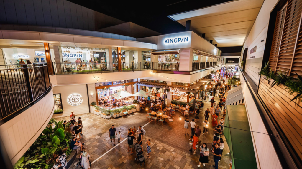
Chermside shopping entre – a hub of entertainment and dining for Brisbane’s northside.
Industry changes 1889-today
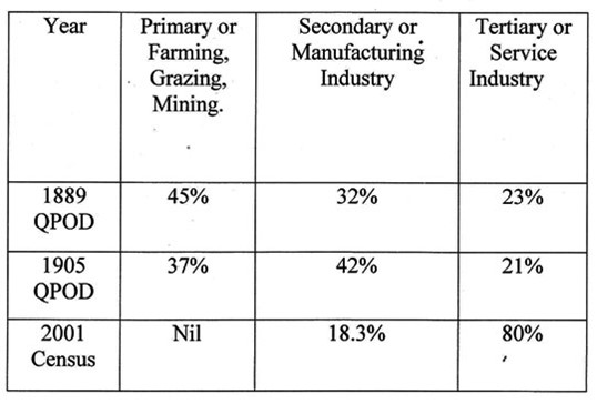
The source for 1889 and 1905 were the Queensland Post Office Directories for the Downfall Creek Area. The 2001 figures came from the Census.
These statistics show the great changes that have taken place in Downfall Creek-Chermside industries over the last 120+ years. The Downfall Creek district was originally a farming area with a manufacturing sector mainly geared to the local farms and the local hamlet of Downfall Creek. It has since developed into the suburban area of Chermside in which industry is dominated by the provision of services with a small but important manufacturing sector.
Industry changes in 2021 Census

To view this table, click here, and scroll down to Income and Work.
Just when you think it has all gone, along comes Norm and his Blue Heeler
While we are looking at the change in the type of industry in Chermside it is salutary to stop and find the exception that proves the rule.
When the Census of 2001 shows that Primary industry is at last extinct in Chermside, down near the place where Downfall Creek goes under Gympie Road, the last grazier in Chermside, assisted by his blue heeler, is quietly tending his herd of cattle.
Admittedly he had come to the end of the road as his lease was up. Norm had created his own little niche mowing the abundant grass in the time-honoured fashion of grazing. The land he used is now under a Tertiary Service Industry, the retirement village of Wheller on the Park.
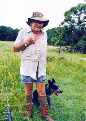
Norm Steers, the last grazier in Chermside. Like all graziers, Norm has a blue heeler which actually worked as a cattle dog in the middle of Chermside. Image courtesy of Robert Isdale 2007.