
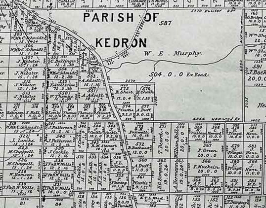
In November 1864, Edward Huxtable had surveyed the future Chermside area and laid out the grid pattern of east-west and north-south roads which are used today. There were no quarter-acre house blocks but paddocks varying in size from 8 to 30 acres with some larger including the 504-acre Murphy’s Paddock on Downfall Creek (1888 Surveyor General’s Map). The hamlet of Downfall Creek developed between Dead Man’s Gully, where Somerset Creek crosses Gympie Road, and Downfall Creek to the north. As the hamlet slowly grew, newcomers bought small acreages for houses and workshops. By the late 1890s some landowners began to subdivide their larger blocks into small house lots.
Possibly the earliest landowner to subdivide his land was Andrew Hamilton on the east side of Gympie Road. Gottlieb Conradi, who owned a store on the west side of Gympie Road also subdivided his land for sale to house builders. The sales were probably slow as Downfall Creek was a fair distance from the Central Business District. The land offered by Hamilton was still being sold in the 1930s.
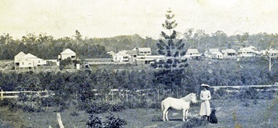
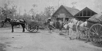
Our earliest photo of the hamlet of Downfall Creek was taken in 1902. It was taken as a Hamilton family photo of Janie Hamilton, later Janie Wayper with her pony Silver and her dog. Fortunately for history, it also shows much of the hamlet in the background. This photo was taken approximately 38 years after the first Crown Lands survey of the area from the present Burnie Brae Park.
In 1865, the first bridge had been built over the South Pine River at Bald Hills and was opened by Governor Bowen. The main road suddenly acquired much more importance, and when gold was discovered the importance grew even more.
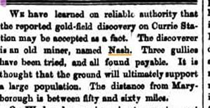
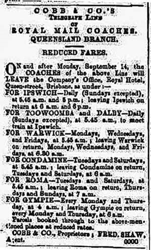
In early 1868 the Queensland Government allocated £2,700 for the construction of a road to Gympie. On 12 November 1868 the first coach left Brisbane driven by Hiram Barnes and arrived in Gympie on Friday evening 13th November 1868.
When Andrew Hamilton travelled to Gympie in 1867 to find gold the trip took him two weeks on horseback and in some places the track was almost impossible to find. He was following a trail blazed by others using trees as markers. There was no road to Gympie then, but by 1868 “the knights of the long ribbons” were driving the coaches of Cobb & Co on a twice weekly, timetabled run from Brisbane to Gympie. The second Northern Road from Central Business District was operational and provided a more direct route to Gympie and Downfall Creek was on that road.
It must be clearly understood that settlement gradually moved out from the early Central Business District in a gradual process to the north and this is reflected in the naming of the main road to the north. The road from Brisbane to Chermside in the very early times was probably just a track marked out but not developed by sealing and bridging. The development of the road in sections was probably marked by the naming of each section. Brunswick Street, the earliest part, goes to Gregory Terrace; Bowen Bridge Road was probably named when the bridge was built over Enoggera/Breakfast Creek, Lutwyche Road when the road was extended to Lutwyche and Kedron Brook. Gympie Road probably marks the building of the road to Gympie in 1868 after the gold discovery in 1867.
Shopping centres appeared in the 19th century in the Brisbane CBD, then Lutwyche, then Chermside, then Aspley. These centres catered for the local area in groceries and fresh food but also had specialist shops and workshops which catered for the more expensive goods which were bought less frequently. Means of transport played a big part in deciding the spacing of the small settlements along the main road just as it does today in the automobile age. In the pre-motor car age people could only travel short distances to do their weekly shopping.
The areas in between were catered for by the widespread corner store, which was oriented to the pedestrian traffic for a short distance around the shop and sold day-to-day items such as groceries and some fresh produce. The perishable items such as bread, meat, ice, rabbits, fish, and green groceries were supplied by horse-drawn carts on a door-to-door basis; fuel such as wood was delivered by the vendor who also might have supplied clothesline props.
When the automobile age began people were willing to travel longer distances and many of the earlier shopping centres were closed; the corner store has now all but disappeared. The hamlet of Downfall Creek was just close enough to Central Business District for a sulky, buggy or spring cart to make a trip with produce to sell at the markets and do some shopping in the process if expensive items such as furniture, a sewing machine, jewellery or art works were to be purchased. On the other hand expensive horse-drawn vehicles were being manufactured and sold in Downfall Creek.
John Patterson chose to build his general store directly to the south of Banfield Street because he estimated that there would be sufficient people living nearby who would choose to shop at his store rather than travel to Lutwyche for their supplies. When he opened his store in 1868 there was no store in Kedron until King’s opened in 1891, possibly because of the proximity to Lutwyche. Why he settled near Banfield Street rather than Hamilton Road is a mystery; maybe he got the land cheaper, but later shops including Conradi and Fisher tended to be south of Hamilton Road; however, Hacker set up on Banfield Street to the east and not far from Patterson’s shop.
Then there seemed to be a stroke of serendipity when Andrew Hamilton came to farm in 1868 but found he could do better by following his trade of carpenter, joiner and wheelwright. He employed the first blacksmith in the hamlet and expanded into cart and carriage building. His son Thomas set up the first fuel depot supplying wood and coke to customers in the Kedron and Lutwyche areas.
This was the beginning of manufacturing in the local area and Downfall Creek grew to dominate in the surrounding district. Smelly, obnoxious industries such as slaughter yards appeared to supply the butcher shops in the growing north Brisbane area. Tanneries, fellmongering and wool scours followed by settling on the numerous creeks to process the sheepskins and hides from the slaughter yards. Building tradesmen such as carpenters, bricklayers, painters, plumbers, fencing, well-sinking contractors came to live and work. Butcher, hairdresser, bootmaker and repairer, draper, saw miller, timber cutters, drover, etc., steadily appeared. A semi-independent village was in the process of growing in the small area along the present Gympie Road between Hamilton & Rode Roads. It was to keep on growing, steadily attracting more businesses.
In his 1973 book, History of Chermside (p.21), David Teague summed up the local business aspect of the early settlement: Chermside is in a rather unique position as far as local business is concerned. It not only services its own district but many surrounding suburbs and it has done this for a hundred years. Chermside was the centre for the coachbuilders and blacksmiths, produce merchants and stores in the 19th century and it continues in a similar modern way today servicing the surrounding areas.
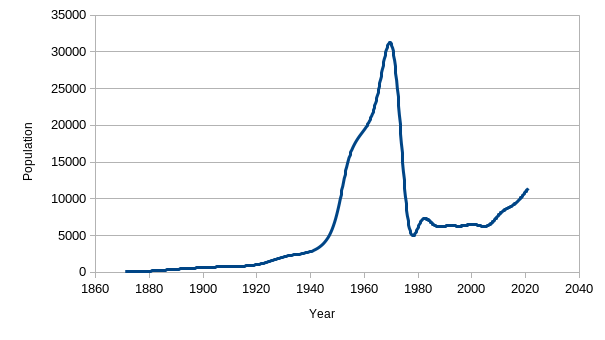
The growth of the village is reflected in the periodical census counts up to about the 1920s. The figures in the graph are the number of people living in the Chermside Statistical Division which included the farming community. Originally the area covered was 15.6km² but in 1975 the boundaries were changed and the area became 3.4km², hence the drop in Chermside’s population.
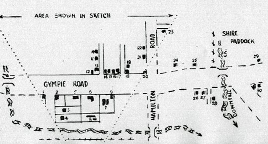
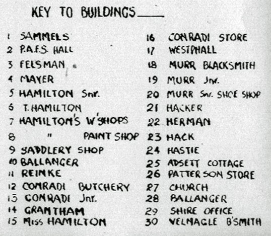
This sketch map of the hamlet of Downfall Creek in 1902 by Stan Eddowes was based on the photograph of Janie Hamilton which was taken in front of the Hamilton’s home of Burnie Brae overlooking the settlement of Downfall Creek (towards the top of this page). The section from the photograph is shown in between the diverging dotted lines. The remainder was plotted from local knowledge. The buildings are keyed into a list of the families living in them. An estimate of the hamlet population can be made for 1902 using the above map, the list of 23 families and an average family size of six persons at the time. Thus Downfall Creek may have had about 140 persons in the 649 listed in the Downfall Creek Statistical Area at the 1901 census.
1864: Edward Huxtable surveys the area of Downfall Creek and leaves the huge 504-acre block around Downfall Creek for posterity.
23 May 1865: First Chermside land sales held in Brisbane.
1866-7: Patterson Store on Banfield Street – taken over by George Early in 1888.
1869: Andrew Hamilton settles in present Burnie Brae Park to farm but turns to making carts, wheelwrighting and blacksmithing.
1873: The Methodist Church founded in a hut on Aaron Adsett’s land – the present Wheller Gardens.
1874: Chinaman’s Creek (now Albany Creek) Road opens – link with Old Northern Road.
1877: New church built on the corner of Banfield Street, which was used for important social as well as religious events. It then moved to the corner of Hamilton and Gympie Roads in 1926.
1879: Postal Receiving Office in Patterson’s store, which could have started as early as 1868 when Cobb & Co began their service to Gympie.
1880s-1890s: Tanneries, Wool Scours, Slaughterhouses/yards proliferate; blacksmiths, general stores. Water was obtained from wells, tanks and creek. Cooking was done using wood-fired stoves. Lighting was candles and oil lamps. Transport was horse and bullock. Houses were timber with galvanised iron or shingle roof. There were no medical, dental, hospital, banking, or legal services.
1880: Gottlieb Conradi opens the Polsloe Store on the west side of Gympie Road.
1884: Kedron Shire offices and clerk’s house built opposite Murphy Road and the first butcher, Daw & Slack opened.
1890s: Lodge Hall built and became the School of Arts in 1909. It was very important social, educational and library centre.
1891: Packer & Knox opened – Fellmonger, Wool Scour, Tanner.
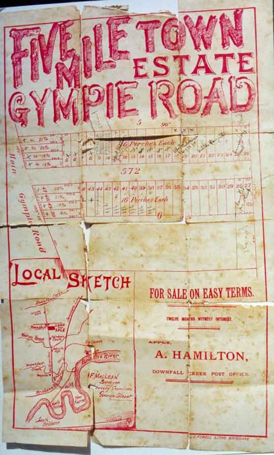
1896: First definite subdivision for housing blocks in Downfall Creek by Andrew Hamilton – Fivemiletown Estate – same area in 1926 with 77 blocks and 1928 with 60 blocks.
1898: Vellnagel’s Blacksmith started on the north-east corner of Murphy and Gympie Roads.
1899: George Conradi butcher shop opened.
1900: Downfall Creek State School opens with 90 pupils.
1902: James Plucknett opens blacksmith shop.
1903: Downfall Creek renamed Chermside
When August and Christiana Vellnagel and family moved into Downfall Creek there was endless space available. He had four acres (1.6ha) on which to build his forge and loads of room for farmers to leave carts for repairs or horses to shoe. There was plenty more room to build a house on the other side of the road and the children could play in the bush, walk down the road to school, and the local shops were an even shorter walk while the Church was just up the hill; they could take a buggy ride into the big city for a day’s shopping. August died in 1932 aged 59 after a stomach operation; there were no antibiotics in those days. Fortunately, he had strong sons who continued the business.
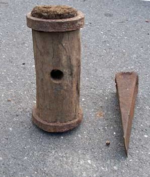
Splitting slabs from a log was the alternative to ripping the log with a pit saw. It was cheaper and rougher and it was widely used for wall timbers in houses and workshops. The maul was made from hardwood and bound either end with iron; the hole was for the handle. It weighed about four kilograms and it took a very fit, strong man to use it all day long. The maul being wood was softer than the iron wedge and did not damage the steel. The splitter put a line of wedges in a solid log and hammered them until the log split. Sounds simple, and it was, but it took a lot of skill to produce good slabs.
In the 47 years since the first land sale in Downfall Creek the hamlet had developed a basic settlement with a population of about 130-140 and at least 37 Sales Outlets. The population of the whole Downfall Creek Statistical Area at the 1901 Census was 649.
General Stores (3): Sammells, Conradi, Hacker
Drapery (1): Grantham
Bootmaker/Shoe Store (2): Hansen, Christopher Murr
Blacksmiths (3): Hamilton, Murr, Vellnagel
Carriage Builder (1): Hamilton (employed up to 14 men)
Government: Post Office, Shire Office, School
Butcher (1): Conradi
Hall (1): Protestant Alliance Friendly Society, Methodist Church, Methodist Church Orchestra
Tanneries (6): Packer & Knox, Pills, Gallagher, Maggs, Slaney, Maunsell
Slaughter Yards (6): Conradi, Cocks; Felsman and others
Builders (2): James Hamilton, Ludwig Hermann
Wood Depots (2): Henry Beneke, Tom Hamilton
Bone Mill/Fertilizer: Mentioned in Kedron Shire Minutes
Carter-Drayman
Sanitary (4)
Saddler (1): G. C. Westphal
1904: First Police Station opened, and closed in 1917.
1908: First telephone in Sammell’s store then moved outside later.
1908: Kedron Shire Cattle Dip opened in Chermside.
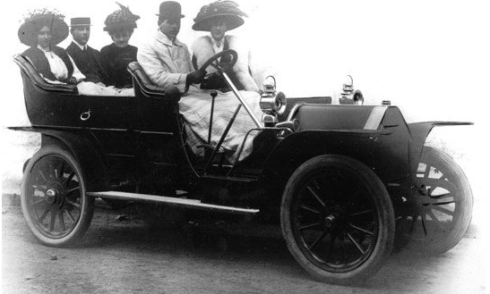
1909: First car in Chermside area, owned by the Early family.
1909: Alonzo Sparkes opened his slaughter yard & butcher (this area later became 7th Brigade Park).
1911: Water main laid along Gympie Road.
1914: All Saints, Anglican Church opened.
1917-21: The Marchant family gave 100 acres of their property to be used as a park and is now Marchant Park.
1924: First automobile service station opened.
1925: Electric light arrives in Chermside.
1925: Electric trams arrive in the district with the last stop at Lutwyche Cemetery.
1928: Dawn Theatre opens with silent films.
1928: Town water to Marchant Park.
1929: Police Station reopened.
1930: R. E. Stevens Sawmill opened, and talkies start at the Dawn Theatre.
1931: Slaughter yards closed.
1933: Census indicates that Chermside could be classed as a small town, possibly the biggest in the Shire.
1936: Wheller Gardens opened.
Town water, electric light, and power, automobiles appearing, postal deliveries, Brisbane newspapers, telegrams.
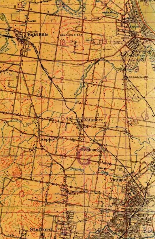
The map of Chermside in 1925 shows how the village has grown on the west side of Gympie Road and south towards Kedron, which is more developed as it is closer to Brisbane. By this time the tram had reached Lutwyche Cemetery and the housing had followed the cheap transport. The main east/west streets are Hamilton and Rode Roads. The minor streets on the east side are Banfield, Kuran, and Kingsmill. The minor streets on the west side are Latham, Sparkes, and Wallace.
To read about Chermside during the 1930s to 1970s, click here.
This text was written by Patrick O'Shea in 2010. It was updated by Bradley Scott in 2021, by Sherry Mackay, Julia van Zon, and Bradley Scott in 2023, and by Bradley Scott in 2025.


All content © 2010-2026 Chermside & Districts Historical Society